

Center for Geospatial Information Technology assists with Blacksburg's storm water management
Virginia Tech's Center for Geospatial Information Technology (CGIT) has partnered with the town of Blacksburg, Va., to implement a research program on storm water management that aims to control the input of pollutants into municipal storm sewers. This program is part of a nationwide initiative called National Pollutant Discharge Elimination System (NPDES), which has been designed by the Environmental Protection Agency (EPA) as part of the Clean Water Act to prevent polluted storm water from entering the nation's waterways.
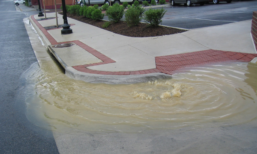
Blacksburg, like most of the American towns and cities, has a Municipal Separate Storm Sewer System (MS4), which is a network of ditches, gutters, and storm sewers that collect storm water, but do not connect with a wastewater collection system or treatment plant. “Pollutants such as excessive amounts of sediments, pesticides from lawns, trash, or grease and oil from roads end up in storm sewers and are discharged into the surrounding streams if storm water infrastructure is inadequate or improperly maintained,” explained Matt Stolte, town engineer, Blacksburg.
The nationwide NPDES storm water program has two distinct phases. Phase I was initiated in 1990 and was applied to medium and large MS4s serving populations greater than 100,000. Phase II started in 1999 and has been implemented by small towns operating a MS4. “Since 2002, under the Phase II, the town of Blacksburg must obtain a MS4 permit from the state to discharge storm water from the town. Renewal of the MS4 permit is on a five year cycle and requires the implementation of practices and ordinances to decrease the quantity and improve the quality of storm water discharged into the local streams," said Stolte.
Aided by the CGIT specialists from Virginia Tech, Blacksburg will carry out several storm water management activities as established by the NPDES guidelines. For instance, the illicit discharges will be detected and eliminated and the construction site runoffs will be supervised closely. Also, there will be plans for the management of post-construction storm water and for conducting public education and outreach activities.
Teams from CGIT and the town will use advanced geospatial technology and equipment: Global Positioning Systems or GPS (a network of more than two dozen satellites that orbit the Earth at 12,600 miles and which send accurate location coordinates to a special GPS receiver), Geographic Information Systems or GIS (a computer-based information system that enables users to superimpose different map layers on top of each other), and slate tablet-PCs (portable computers specifically designed for outdoor use).
The Center for Geospatial Information Technology is currently creating an inventory of Blacksburg’s existing storm sewer infrastructure using a GIS database structure which can be expanded as subsequent phases of work are funded.
“Among other activities, we will create an extensive record with field data about the location of various features of Blacksburg’s storm sewer system using slate tablet-PCs and GPS units,” explained Randy Dymond, associate director at CGIT and associate professor of civil and environmental engineering in the College of Engineering at Virginia Tech. “These new slate tablet-PCs offer the best image quality in bright sunlight which is very important when conducting field research.”
Blacksburg invited CGIT to showcase its planned activities for the MS4 project during Blacksburg’s Watershed Open House this past October. “We were happy to participate at the Open House because it gave us the opportunity to talk to citizens interested in environmental issues. I think we learned a lot just by hearing their concerns and questions, and they were able to learn about our goals, methods, and techniques,” said Dymond.
The Center for Geospatial Information Technology at Virginia Tech functions as a dual-campus, interdisciplinary research center that specializes in cutting-edge geospatial data analysis and applications. The center’s staff and affiliated faculty provide expertise in a variety of areas, such as infrastructure and transportation, natural resource and hazard mitigation planning, environmental management, homeland security, wireless communications, and public health.
.jpg.transform/m-medium/image.jpg)